Kategoriat
Geomachine Oy
When selecting a ground investigation rig, the first step is naturally to ensure that the new equipment is compatible with your investigation methods. But what other questions often arise during procurement discussions? That’s what we’ll explore in this article.
Geomachine currently offers a selection of seven different rigs, each designed for specific investigation methods. With such a wide range of options, it’s essential for ground investigation companies to have enough information to make the right purchasing decision.
Geomachine’s Sales Manager Alex Lindholm has helped numerous companies in the field select the most suitable and effective tools for their needs. A successful choice always stems from open dialogue. “Even if we’re dealing with a seasoned expert in the ground investigation industry, we never skip the step of mapping out the rig’s intended applications during procurement talks. It’s important to thoroughly assess the client’s current situation and make sure they’re aware of all the options that best meet their needs at this point in time.”
These three questions are the most common
Ground investigation is a highly specialised and relatively small field. For this reason, those working in the industry are usually well informed about the equipment options and manufacturers available. “A client who already knows us typically enters procurement talks with a specific machine model in mind. They may already have some experience with that model, making the discussion quite straightforward. However, even if the base machine is familiar, many are surprised to learn just how smart these rigs can be nowadays. That’s why we always take time to talk about how our digital services can now help optimise tasks such as machine maintenance, servicing, equipment management, and project planning.”
New clients often come with three standard questions. “They usually want to know whether the rig is compatible with their current method, whether it has enough power, and whether it can reach the necessary depths. These are easy questions to answer. All Geomachine rigs are absolutely capable of performing the methods they were designed for.”
The best choice now – but what about the future?
The ground investigation industry evolves alongside changes in its operational environment. According to Alex Lindholm, there is currently high demand for larger rigs that can be used for deep investigations. Market shifts often raise concerns among clients, and these are addressed during discussions. “No one can say for certain which investigation methods will be in highest demand in the future. The good news is that if you invest in a more robust rig now to meet current needs, it can often still be used for lighter methods as well. For instance, all our rig models can perform vane testing. This often comes as a surprise during discussions.”
When looking to the future, every client is also interested in how the machine will be maintained after the purchase. “We always talk about how future maintenance and spare part needs will be handled. With us, there’s no need for concern – our maintenance and support services are professional and readily available whenever needed. This part of our business is constantly evolving. A recent example is our new field service concept. We’ve recently doubled our field capacity, meaning that help is now available very quickly when needed.”
At the time of purchase, the client may not yet have a clear idea of which technical features would be ideal for the tool. “Sometimes clients only realise what features they want once they’ve started using the machine on an actual site. And that’s completely fine. During the next scheduled service, we can simply add the features the client wants.”
Brand loyalty built on preferences
User preferences also play a major role in choosing equipment. Once you get used to working with a particular brand and it proves reliable, brand loyalty tends to stick.
“It’s a bit like choosing a car. When a certain brand appeals to you for whatever reason, there’s little reason to switch. Those in the ground investigation industry who favour Geomachine rigs typically appreciate their durable build, easy mobility, smart features, and reliable maintenance and support. These are the practical reasons why they continue to choose our machines year after year.”
Interested? Contact Geomachine!
Geomachine Oy
The purchase price of an electric ground investigation rig is still higher than that of a diesel-powered one, which may lead some to question whether the investment is worthwhile. In this article, we explain why an electric rig is a smart long-term choice.
The price difference between diesel and electric ground investigation rigs is mainly due to the cost of batteries and the high-voltage components required by electric rigs. Although an electric motor is simpler and cheaper than a diesel engine, the control system for the motor and battery involves more components, which adds to the overall cost of the rig.
It’s reasonable to expect that as legislation continues to tighten to promote emission-free ground investigation, and as electrification becomes more widespread and battery demand increases, manufacturing costs will decrease. However, investing in an electric rig already makes sense. When comparing its purchase price to its total lifecycle cost, an electric rig is a sound investment even at current price levels.
Fewer breakdowns, more productive working days
Electric rigs require maintenance just like diesel versions, but electric motors need less attention due to their simpler structure. The motor is virtually maintenance-free—there’s no need for oil or filter changes, for example. In practice, servicing the electric powertrain involves inspecting the battery pack, components, cables and connectors. As with diesel engines, coolant must be replaced every two years.
Because there are fewer potential failure points in an electric motor, the result is naturally fewer unplanned downtime days. And downtime is costly—not only because of direct expenses, but also due to potential loss of revenue, late delivery penalties and reputational damage.
Meeting future demands
The most significant driver of electrification is increasingly strict legislation. The EU has already introduced Stage V emission limits, with even stricter regulations on the horizon. In the Nordics, cities like Oslo, Copenhagen and Stockholm already require zero-emission machinery on certain worksites. In public tenders, emission requirements such as compliance with at least Stage V standards or full zero emissions are becoming more common.
As legislation tightens, national and EU-level support for electrification is also increasing. In Finland, for example, the Ministry of Economic Affairs and Employment has funded electric machinery pilots, while at EU level, initiatives such as InvestEU and the Green Deal have offered funding for SMEs.
The ability of an electric rig to meet future legal requirements makes it a worthwhile investment for ground investigation companies that aim to look beyond the near future. Electric rigs are also more resilient to anticipated changes in fuel distribution over the next decade.
Perception matters, too
For a company to succeed today, responsible practices are no longer optional—they are expected. Not only authorities but also customers and stakeholders increasingly demand accountability. Investing in electric machinery is no longer just about image—it’s a practical response to modern-day expectations.
In addition to being an excellent technical choice, acquiring an electric rig also sends a powerful message: the company is a front-runner and pioneer in its field, committed to responsible business and long-term vision.
Interested? Contact Geomachine!
- Digital innovations
- Electrically powered ground investigation
- Geotechnical
- Geotechnical investigation
Geomachine Oy
The electrification of work machines is well underway in the construction, mining, and logistics sectors. As we’re still in an early transitional phase, adopting new technological solutions may raise numerous concerns. In this article, we address the most common of these.
Electrifying work machines is no longer limited to individual pilot projects. We’ve now entered a phase where, in addition to customer requirements, product development is driven by increasingly stringent legislation and societal pressure to shift toward zero-emission operations.
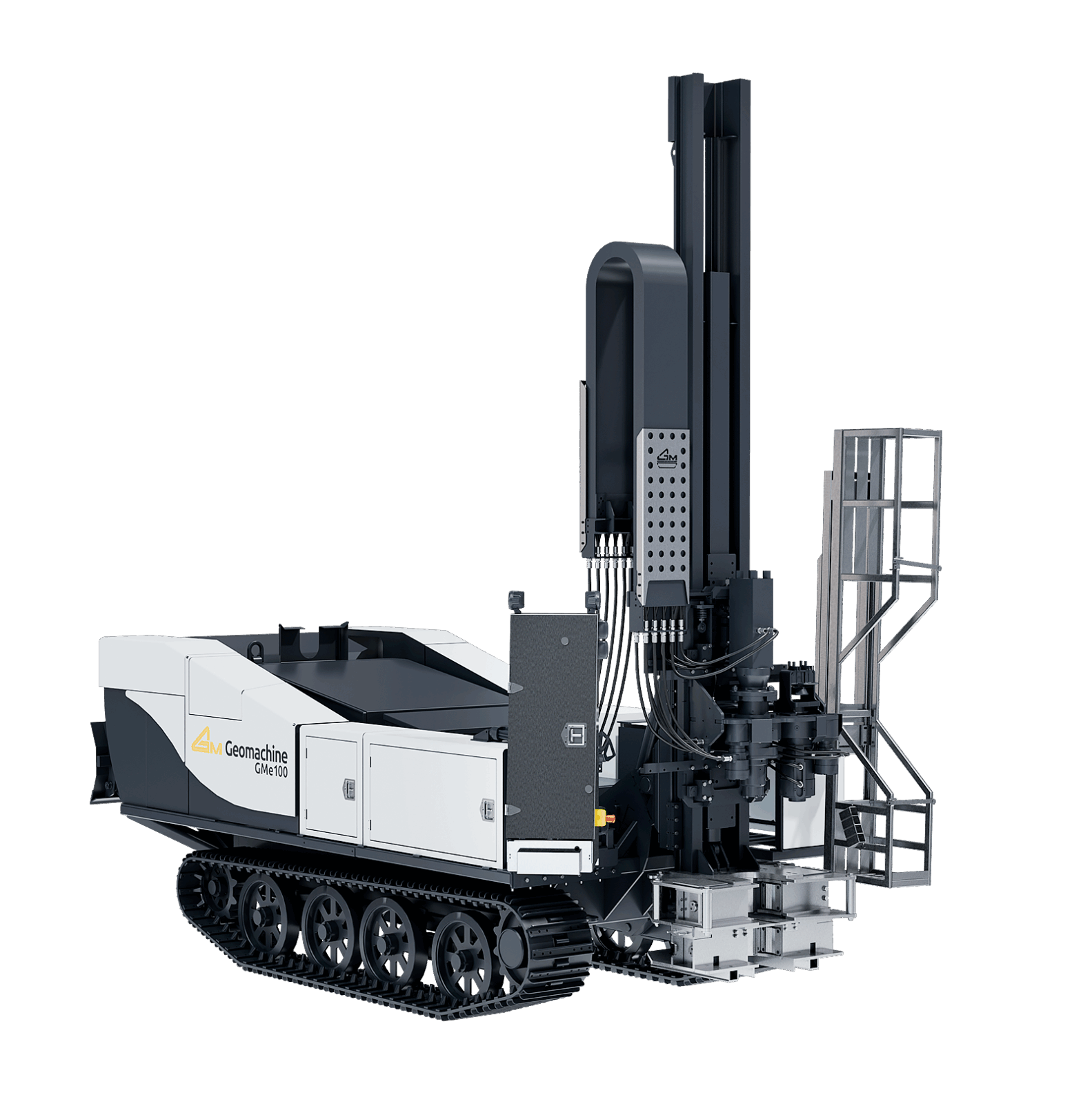
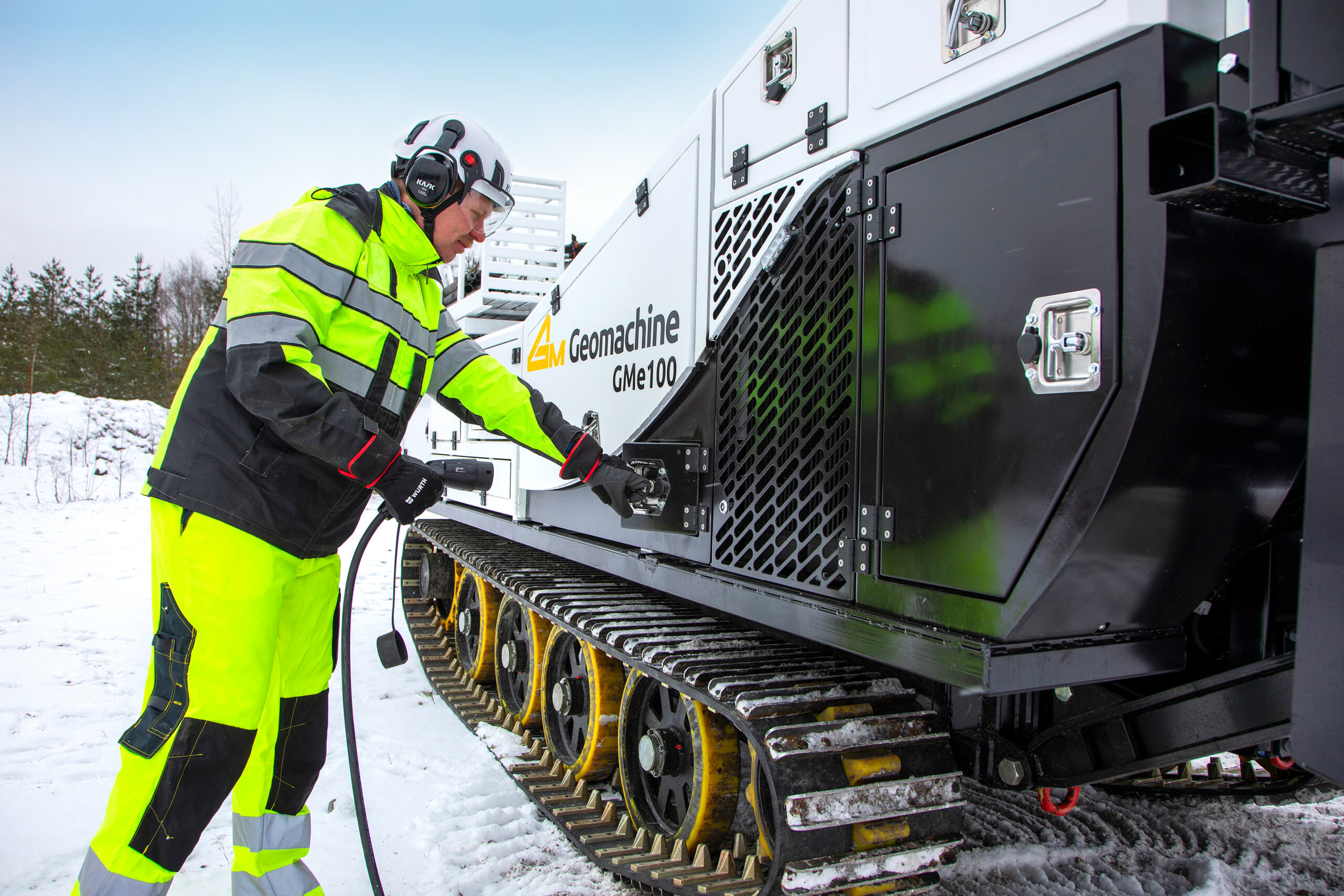
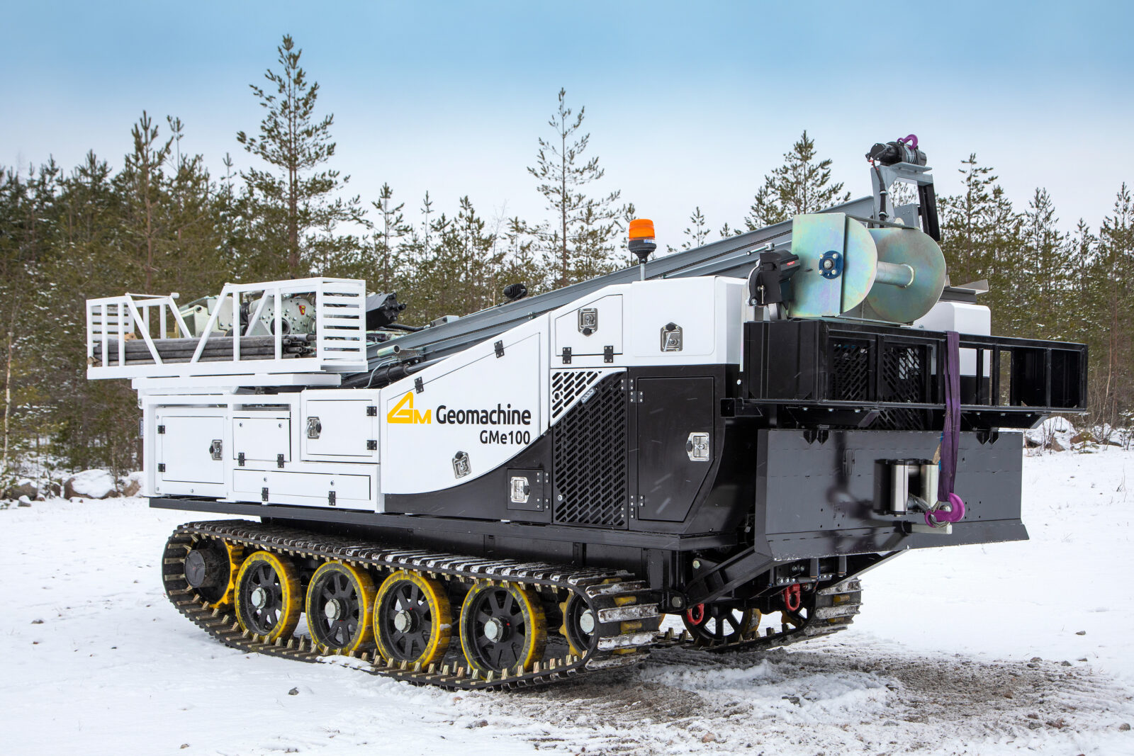
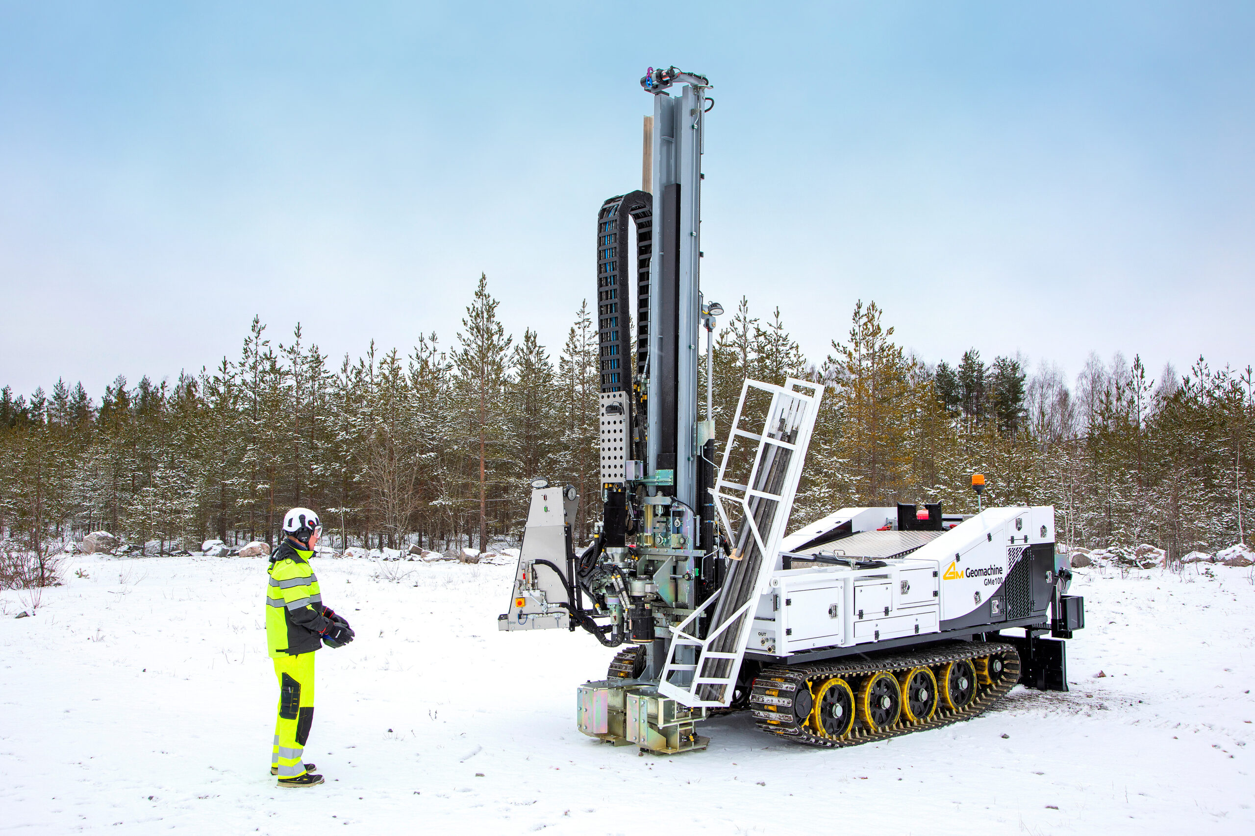
The Geomachine GMe100 is a fully electric ground investigation rig, launched onto the market in early 2025. Its development continues as customer feedback and changes in the operating environment are incorporated. Since electrification in the ground investigation sector is still a relatively new topic, purchasing an electric rig can raise doubts—for instance, regarding its reliability, usability, and maintenance.
Is the battery durable, and where can it be charged?
Battery technology has advanced rapidly in recent years. The proliferation of electric cars has been a strong driving force behind this, and new battery technologies are now increasingly being used in mobile work machines.
Lithium-ion batteries are the most common type. Battery packs are continuously becoming smaller and lighter, yet they can still deliver several hours of operating time in the mid‑size work‑machine category. Mechanical durability and discharge power of batteries have also improved. This is critical, especially for work machines, which may operate intermittently and include power‑demanding peaks.
Charging infrastructure is evolving rapidly. In the Nordics, infrastructure is the most advanced relative to population size—particularly in Norway, whose charging network ranks among the leading in the entire EU. This trend is expected to continue, spurred by ongoing EU programmes. The aim is to have charging stations every 60 km along key routes.
Does it operate in cold conditions?
Battery endurance is crucial for the functionality of a ground investigation rig in cold conditions. Thermal management and cold‑tolerance features of batteries are continuously improving. This advancement has made it possible for electric work machines to operate reliably even in subzero temperatures.
Diesel‑powered ground investigation machines use urea to control harmful emissions. However, urea introduces challenges in cold conditions—freezing at –11 °C can lead to nozzle blockages, pump and hose damage, and even failure to start. These problems are absent in electric rigs because urea is unnecessary. In cold conditions, this may actually make electric rigs more reliable than their diesel counterparts.
Is maintenance of the rig difficult?
Availability of spare parts for the electric rig may be a concern. The rig is equivalent to a diesel rig except for its power source, so most spare parts needs are similar.
Geomachine maintains substantial spare‑parts inventory alongside its production facilities; some parts are even machined in‑house. Therefore, spare parts for the electric rig can be delivered the same day if needed. For rarer parts ordered from external suppliers, delivery times are naturally longer.
Electric rigs require less maintenance than diesel‑powered ones because the electric motor has fewer failure points. There’s no need for engine oil changes or air and fuel filter replacements, and the components of the electrified powertrain are nearly maintenance‑free.
Maintenance of the electric powertrain mainly involves inspecting the high‑voltage battery, cables, and connectors. Cooling fluid must still be replaced every two years, just like in diesel rigs. The rest of the rig is maintained in the usual manner.
Is the electric machine difficult to operate?
Don’t fear using the electric rig because it’s more complicated than the diesel model—because it isn’t. All Geomachine rigs share the same operational logic and basic functionalities, regardless of powertrain. The only new skill needed is how to charge the battery and plan charging.
You could even argue that using an electric rig is simpler than a diesel one. Starting it is easier—no pre‑heating or warm‑up needed. You get full power from the electric motor immediately, there’s no gear shift to manage, and you don’t need to monitor urea levels.
The electric rig is also fully compatible with equipment used on diesel rigs.
Purchase price or future potential?
Money still strongly influences purchasing decisions by ground investigation firms—understandable, of course.
However, transitioning to electric ground investigation—perhaps gradually—is worth considering now. According to research, the market for electric mobile work machines could grow by 10–15 % annually until 2030 (sources: IDTechEx, BloombergNEF). Meanwhile, legislation pushing toward zero emissions will tighten, making electrification a baseline requirement.
Ground investigation firms that look beyond the purchase price and understand the industry’s trajectory and future themes now position themselves as responsible pioneers.
Interested? Contact Geomachine!
Geomachine
Adopting digital tools for ground investigation is easy with Geomachine’s guidance. You don’t need to understand the technology or speak in complex terms. All you need to know is the direction in which you want to develop your operations.
“In the ground investigation industry, things have been done the same way for years, using familiar methods,” says Pasi Majakangas, who designs digital services for Geomachine. “Learning something new alongside your regular work can seem like a burden, so often, people prefer to stick with familiar practices. But what if embracing new solutions was made easy, and it turned out to be a smart and effortless investment from a business development perspective?”
Two ways to adopt
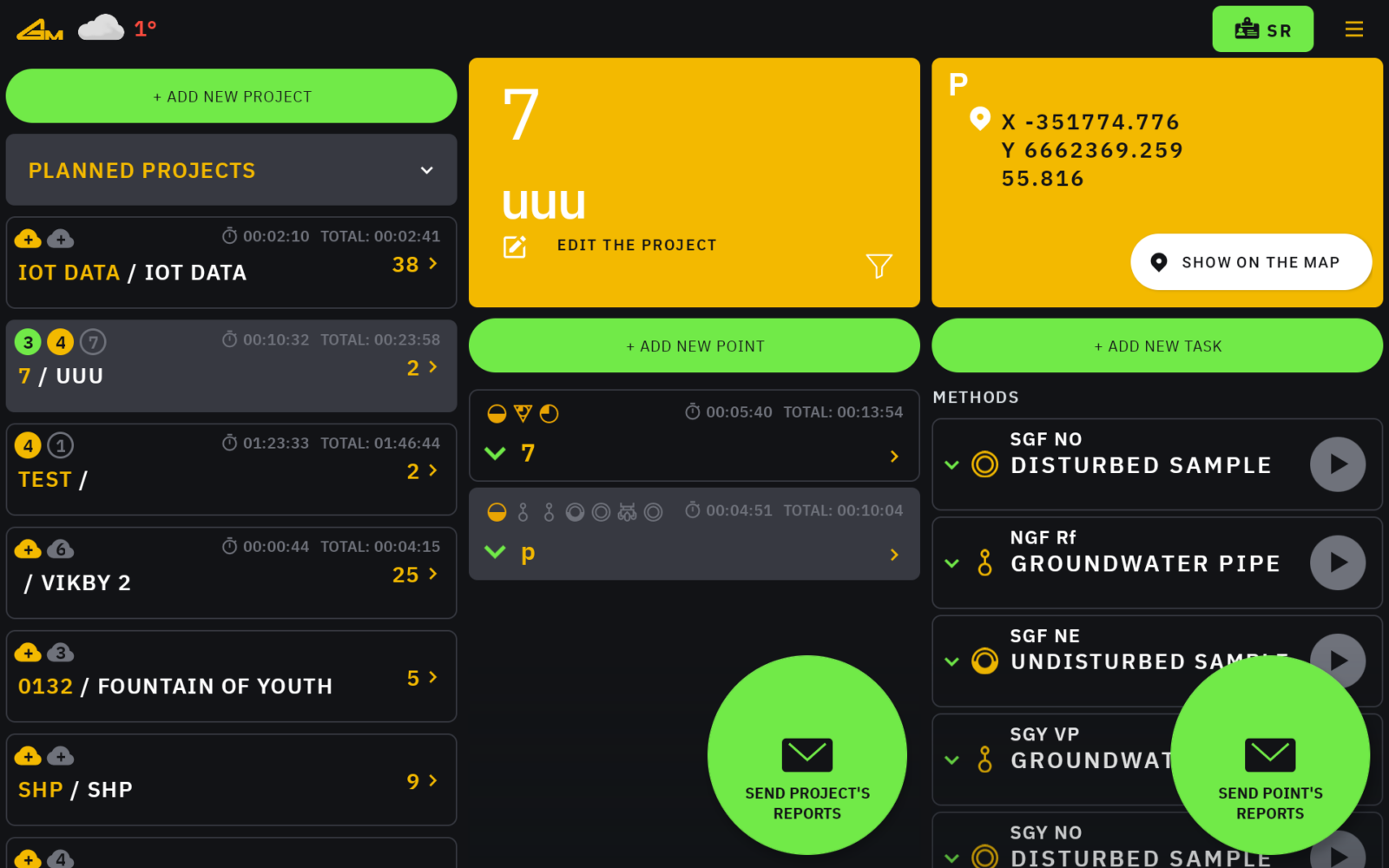
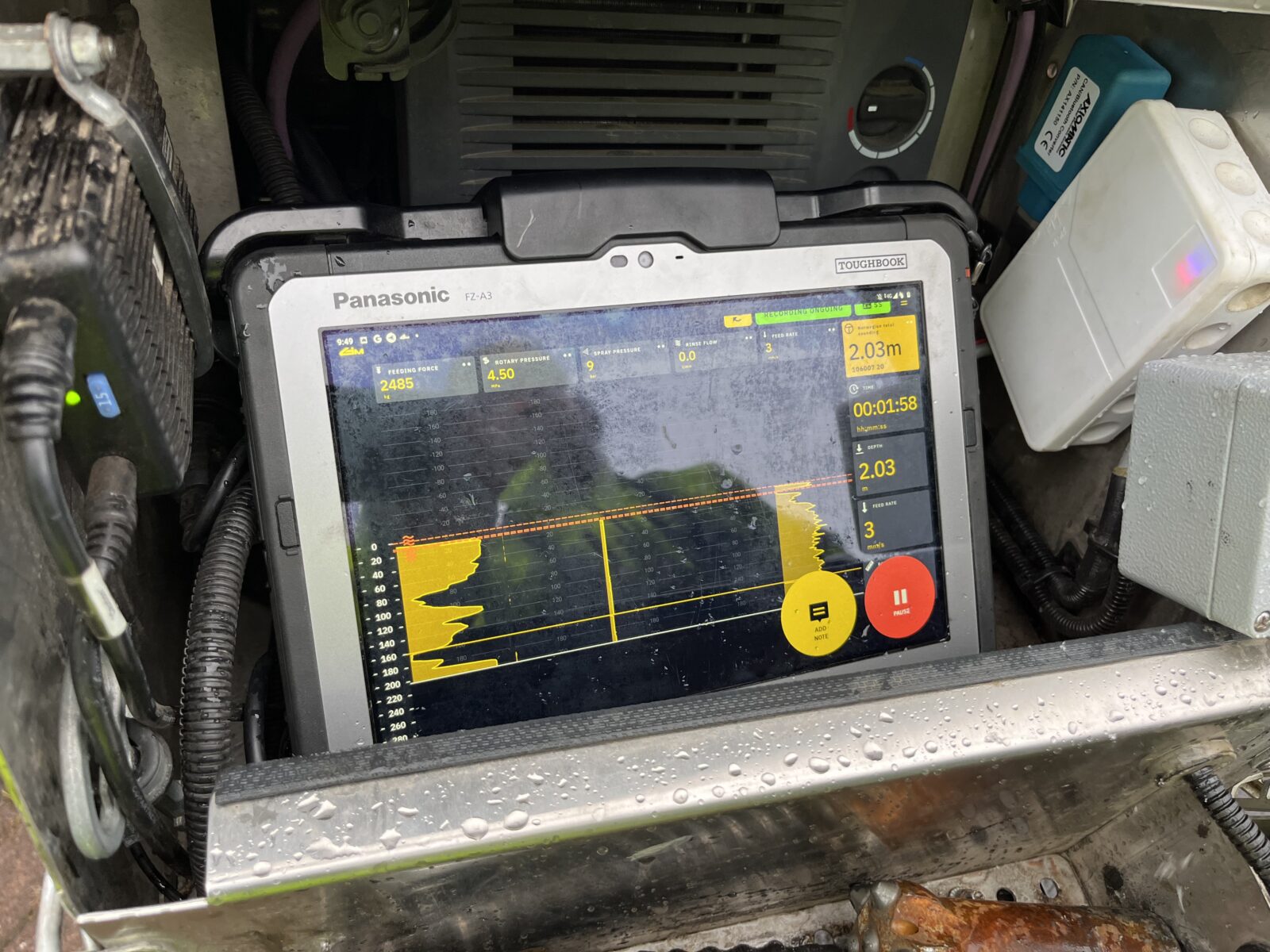
The core of Geomachine’s digital product family, the GMTracker data-logger, is automatically included with the purchase of a new machine. The data-logger can also be added to a machine already in use on-site.
Since digital tools are still relatively new in the ground investigation industry, discussions about their adoption are always led by the customer’s workflows, challenges, and needs, rather than product features. “Some of our customers know exactly what smart features they want from their new machine, and these are added to their GMTracker during the machine’s production phase. Other times, the customer might not have a clear vision of the best solutions for their specific operations. In those cases, we ask the right questions and determine the goals they have for the machine and their business development.”
The customer may also have identified pain points in their operations that they need solutions for. “If the areas that need improvement are already known, we focus on how our digital tools can help resolve these issues. If the goal is simply to get more out of their machines and processes, we’ll explain what’s possible with our digital services.”
Real-life examples
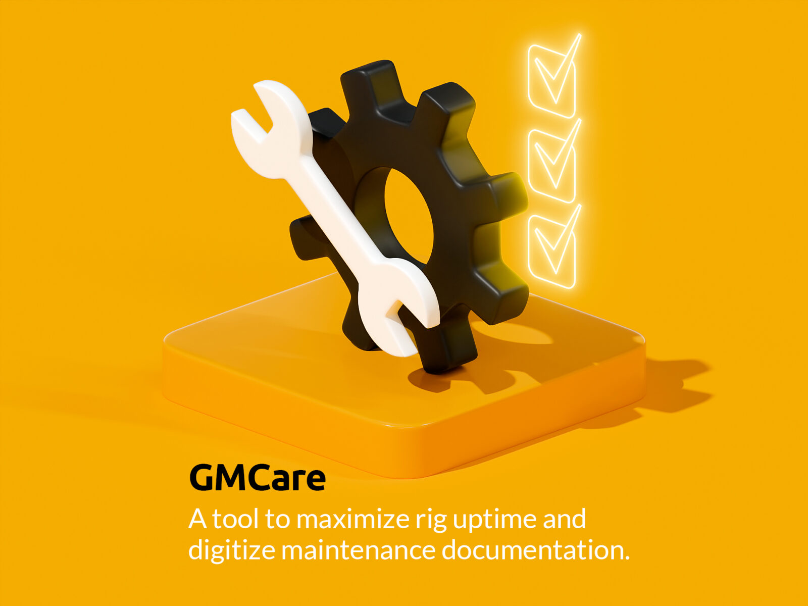
Pasi Majakangas shares that one issue may be long downtime due to maintenance queues, leading to slow and unprofitable project completion. “In such cases, we suggest adopting GMCare. It opens a two-way connection between the operator, machine maintenance manager, and service partner. The software gives the service partner a real-time view of the equipment’s condition, enabling preventive actions to reduce machine failures. GMCare also digitizes and standardizes maintenance documentation, storing it centrally in one place. The software uses machine learning to continuously build a knowledge base, making future machine maintenance more individualized and predictive.”
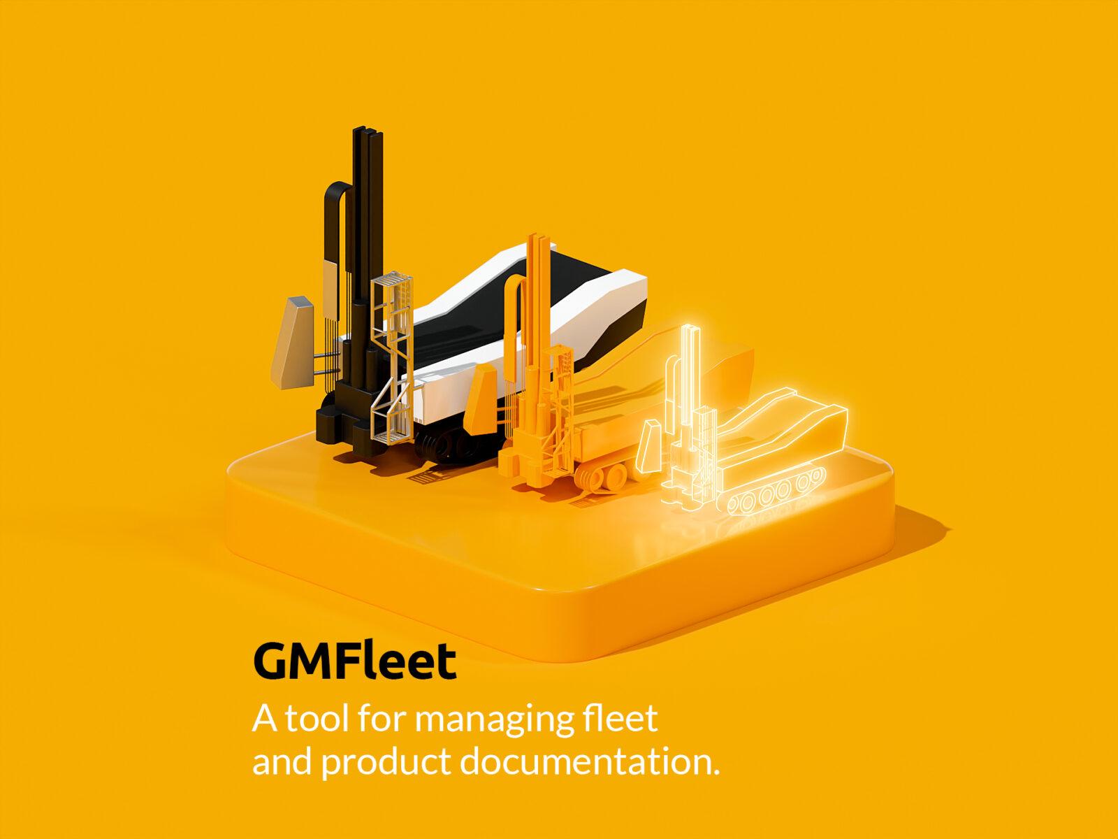
Another issue might be keeping the machine documentation up to date. “In that case, we suggest using GMFleet. This ensures all relevant equipment information is always available in real-time and kept up to date. GMFleet contains all the information related to the machine, including technical documentation and lifecycle data. It also provides easy access to information about the machine’s technical capabilities.”
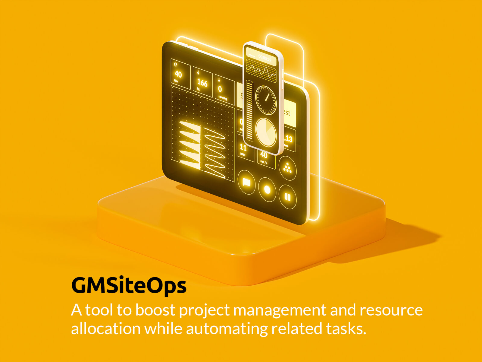
A customer might also struggle with communication issues that slow down project progress. “In such cases, we recommend using GMSiteOps. It streamlines project management and resource allocation, automating related tasks. It digitalizes the project manager’s workspace and integrates it into the project’s value chain. GMSiteOps improves process transparency, real-time data, quality, and safety, while helping to transform the data collected from processes into business-driving actions.”
So, how to move forward?
If you’re interested in improving your business, the right place to start the conversation is with Geomachine’s Sales Manager, Alex Lindholm. “You can email or call Alex. He will arrange a meeting with you to review your business and needs. After the meeting, you’ll receive a proposal for the digital features that can help you reach your goals. If you’re integrating digital tools into an existing machine, the software installation will typically take 1–3 working days. It’s important to consider this when planning your project schedules.”
For those buying a new machine, the process is even easier. “Digital services are always offered with a new machine purchase, allowing you to share your operational optimization goals with our sales team. When the machine leaves the factory, it will already have all the intelligence you wanted pre-programmed.”
According to Pasi Majakangas, there’s no need to fear digital services. “Our product family is easy to understand and use, and our customers who already use the tools agree. If you want to boost your productivity and improve the quality of the data you collect, don’t hesitate to contact us. We’ll tell you which of our tools best suit your needs and how to get them up and running quickly.”
Interested? Contact Geomachine!
Geomachine
Geomachine aims to make ground investigation as efficient, profitable, and high-quality as possible. That’s why it develops cutting-edge digital innovations that will lead the industry into a new and smarter era.
Continuous development is deeply embedded in Geomachine’s DNA. In recent years, the company has focused particularly on digital innovations in its product development to enable companies in the ground investigation industry to conduct their business more intelligently and profitably.
“In the ground investigation industry, traditional methods have often been used, resulting in many manual workflows and fragmentation in the value chain,” says Pasi Majakangas, who designs digital services for Geomachine. “Four years ago, we initiated the development process for digital products with the aim of tackling these challenges.”
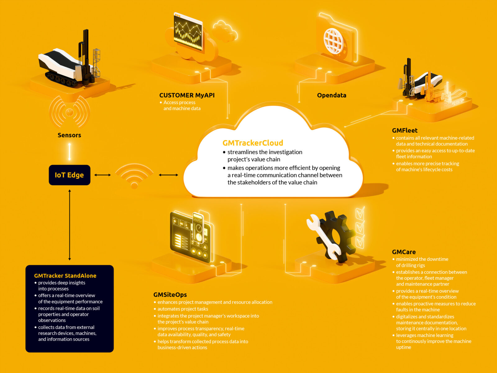
Geomachine’s digital product family currently includes four innovative tools. “The heart of our product family is the GMTracker data-logger. It is an extremely smart tool that provides full visibility into the investigation processes and gives an overview of the performance of the equipment used. In its StandAlone version, GMTracker works locally as an operator tool, and in its Cloud version, it creates a real-time, two-way connection between all project stakeholders. The Cloud version can also be extended with modules such as GMCare, which enhances machine maintenance and servicing, GMSiteOps for optimizing project management and planning, and GMFleet, the equipment registry.”
Step by step forward
As with all of Geomachine’s product development projects, the planning and development of the digital product family involved strong customer collaboration. “In the development of the GMTracker data-logger, we received invaluable support and insights from our long-time customer, Aluetaito Oy. They were involved in the project from the very beginning, and through iterative work, we developed the data-logger to the point where it could be launched to the market.”
The first version of the GMTracker data-logger was made for research methods used in Finland, and later versions were developed for Sweden and Norway. “From a product development perspective, the initial challenge was that there was considerable variation in the needs and practices of companies in the ground investigation industry. A single software solution for everyone was not an option at that point, so the product had to be configured individually for each customer’s specific needs. We focused heavily on customization in our product development. Today, customizing GMTrackerCloud to meet the unique needs of customers can be done with just a few clicks.”
Once the first version of GMTracker and its project management features were up and running, the product development moved forward. “In the next phase, we began considering solutions to enhance machine maintenance and servicing and improve equipment management transparency. These challenges were addressed with the development of the GMCare and GMFleet tools.”
Toolbox expands as needed
According to Pasi Majakangas, no other digital product family like Geomachine’s is currently available on the market. “Until now, individual tools could be purchased from various providers. However, this has resulted in customers having to manage a system architecture that could become messy and difficult to handle. Each program had to be learned separately, and integrating them could require a lot of effort. Managing the whole is now much smarter and easier when all the essential tools can be obtained from one provider.”
One of the strengths of Geomachine’s digital product family is its scalability. “Our products adapt to the needs of the user. You don’t have to purchase the entire extensive toolbox at once; it can be expanded as needed.”
Once all the innovative features of GMTrackerCloud are activated, it provides solutions for the efficient and data-driven execution of the key tasks in ground investigation projects. The transparency of supply chains immediately increases project efficiency, reduces equipment downtime, improves fleet management, and reduces the amount of manual, unnecessary work. In the long term, projects become more productive continuously, as machine learning makes maintenance and servicing operations more predictive. Data on operations and equipment performance constantly increases, helping to make the overall operation more profitable over time.
Continuously smarter and more versatile
Pasi Majakangas says that the development of the digital product family is still ongoing. “In the future, our product family will include even more analytics and 3D visualization features. With these, for example, risk assessments and quality assurance on work sites will be done even more efficiently. The drill rig will learn to identify ground characteristics and automatically suggest them to the driller. Additionally, it will take care of its own maintenance and identify its own issues. This way, maintenance can be performed as soon as the machine starts to show signs of failure, even before an actual breakdown occurs.”
Geomachine’s digital tools are currently in use by leading companies in the ground investigation industry in Finland, Sweden, Norway, and Iceland. “Every ground investigation company that understands that project productivity requires transparency across the value chain can benefit from our innovations. We want to enable our customers to focus on the right things. Do more with less – that’s what we want to offer our customers in a nutshell.”
Interested? Contact Geomachine!
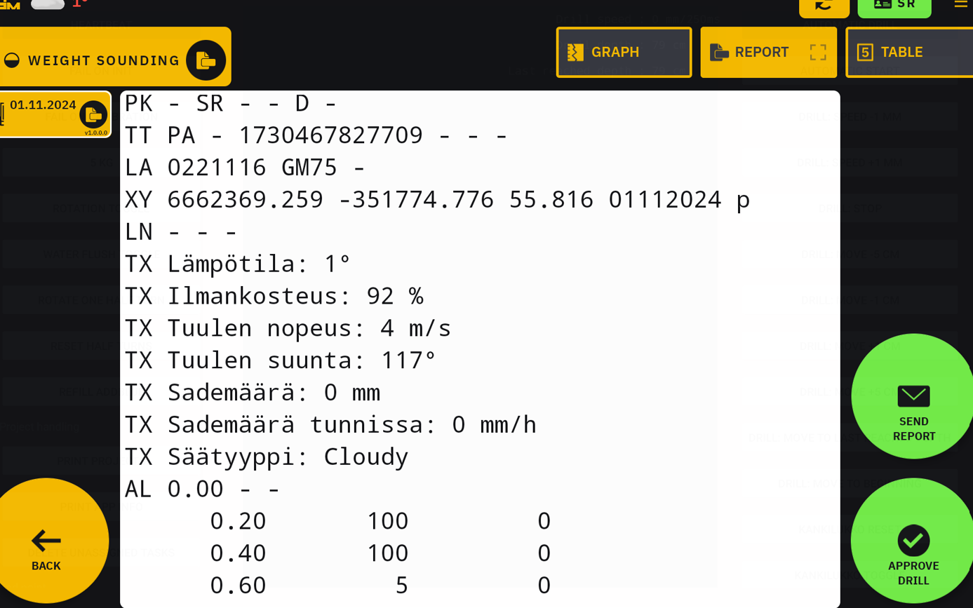
GMTracker
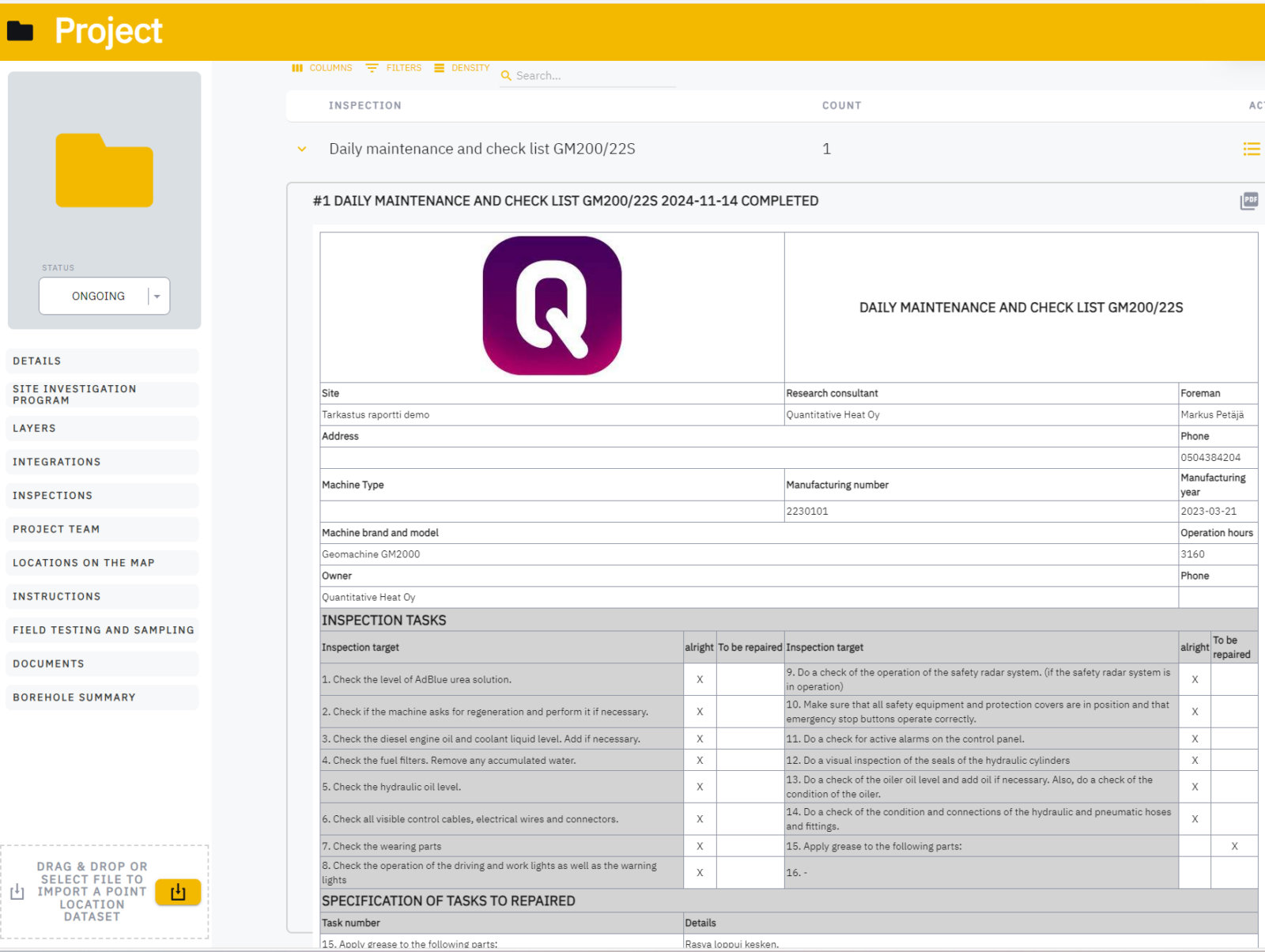
Information about the geotechnical field equipment used in ground investigations must be documented in the investigation report. Thanks to a new feature in the GMTracker data-logger, data on equipment is now transferred to the investigation report without manual effort.
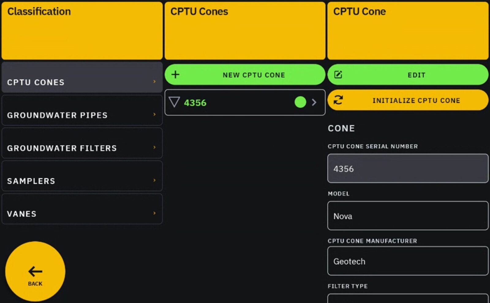
The equipment required for ground investigations include, for example, CPT cones, vane shear devices, and sampling tools. These details must also be recorded in the work report for the investigation.
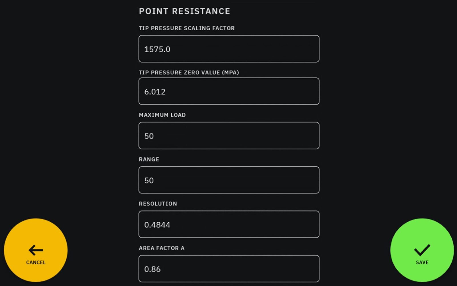
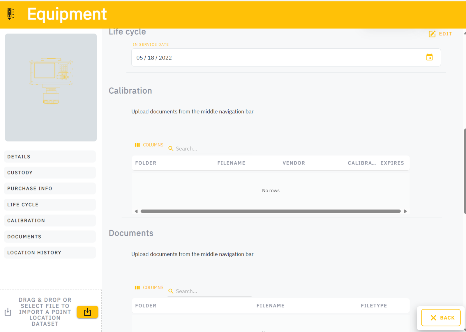
The new feature added to the GMTracker data-logger enables the maintenance and automatic adding of equipment data in work reports. The equipment registry contains information on the device’s identifier, model, type, and calibration, depending on the device. GMTracker is the only data-logger on the market whose registry also includes sampling tubes. Thanks to this new feature, equipment data is always accurately recorded in reports.
In the future, equipment management will also be integrated into the Cloud version of the GMTracker data-logger. Once data can be stored in the cloud, all stakeholders requiring equipment information will gain a comprehensive view of the devices used by the investigation company, their age, condition, and calibration status.
Managing specialized equipment through GMTrackerCloud will not only enhance reporting but also streamline the execution of investigation projects. It will help project management allocate sampling tasks to specific investigation vehicles without needing to transfer equipment from other sites. In the future, calibration values for equipment will also be manageable via GMTrackerCloud.
Interested? Take contact!
GMTracker
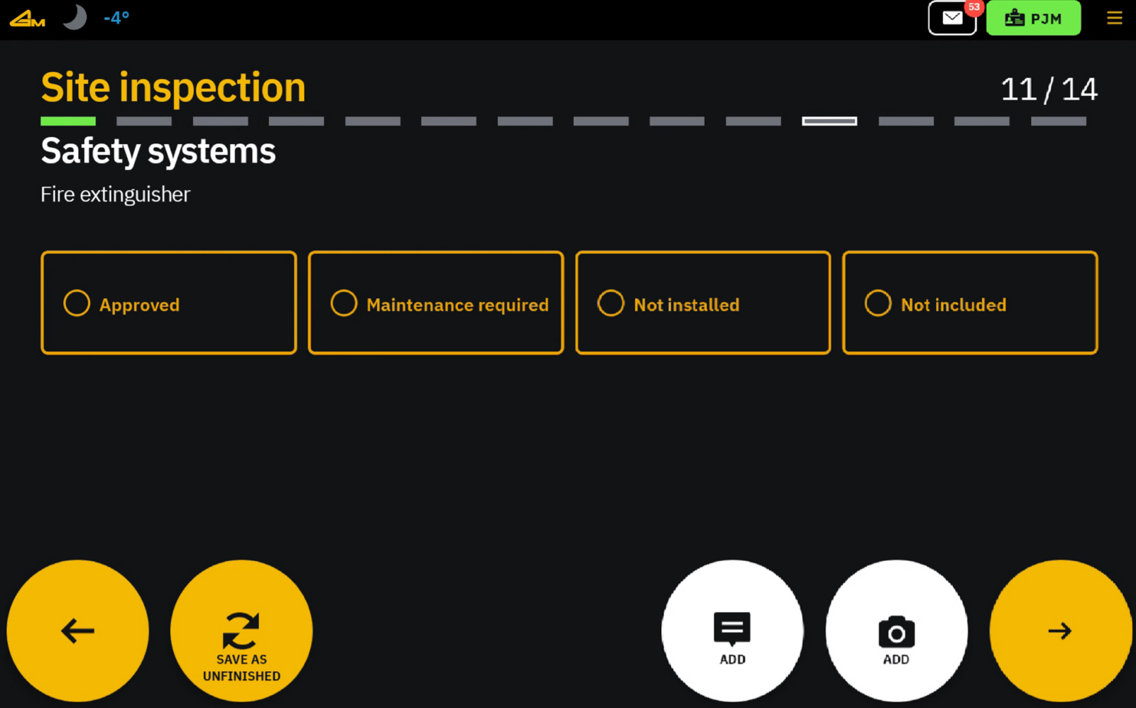
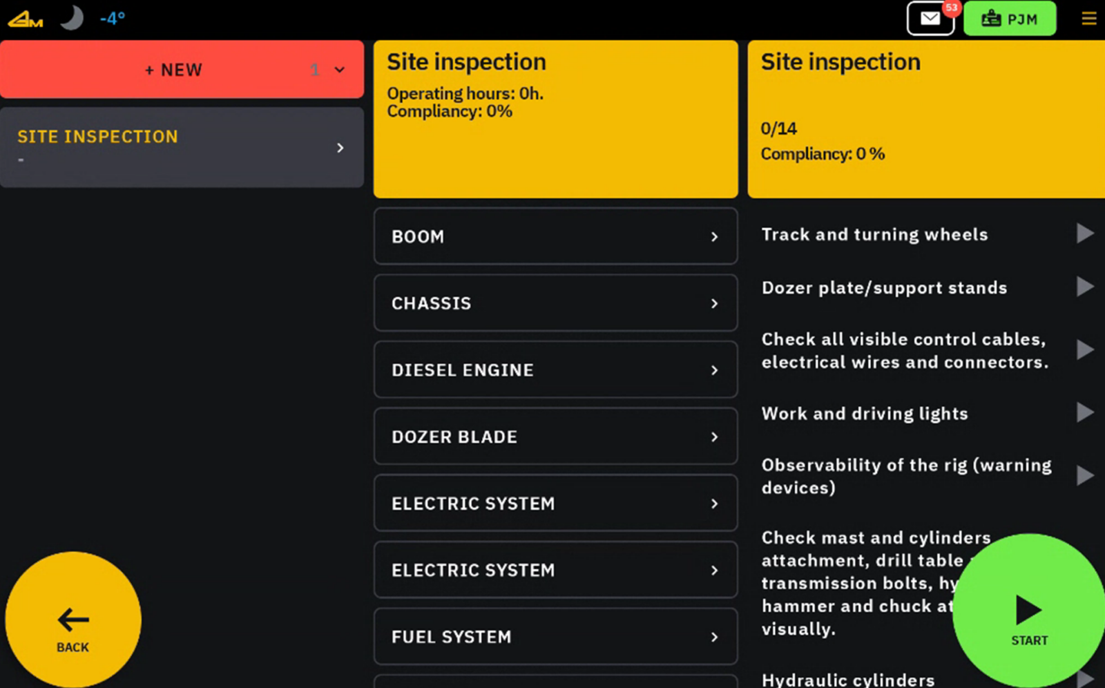
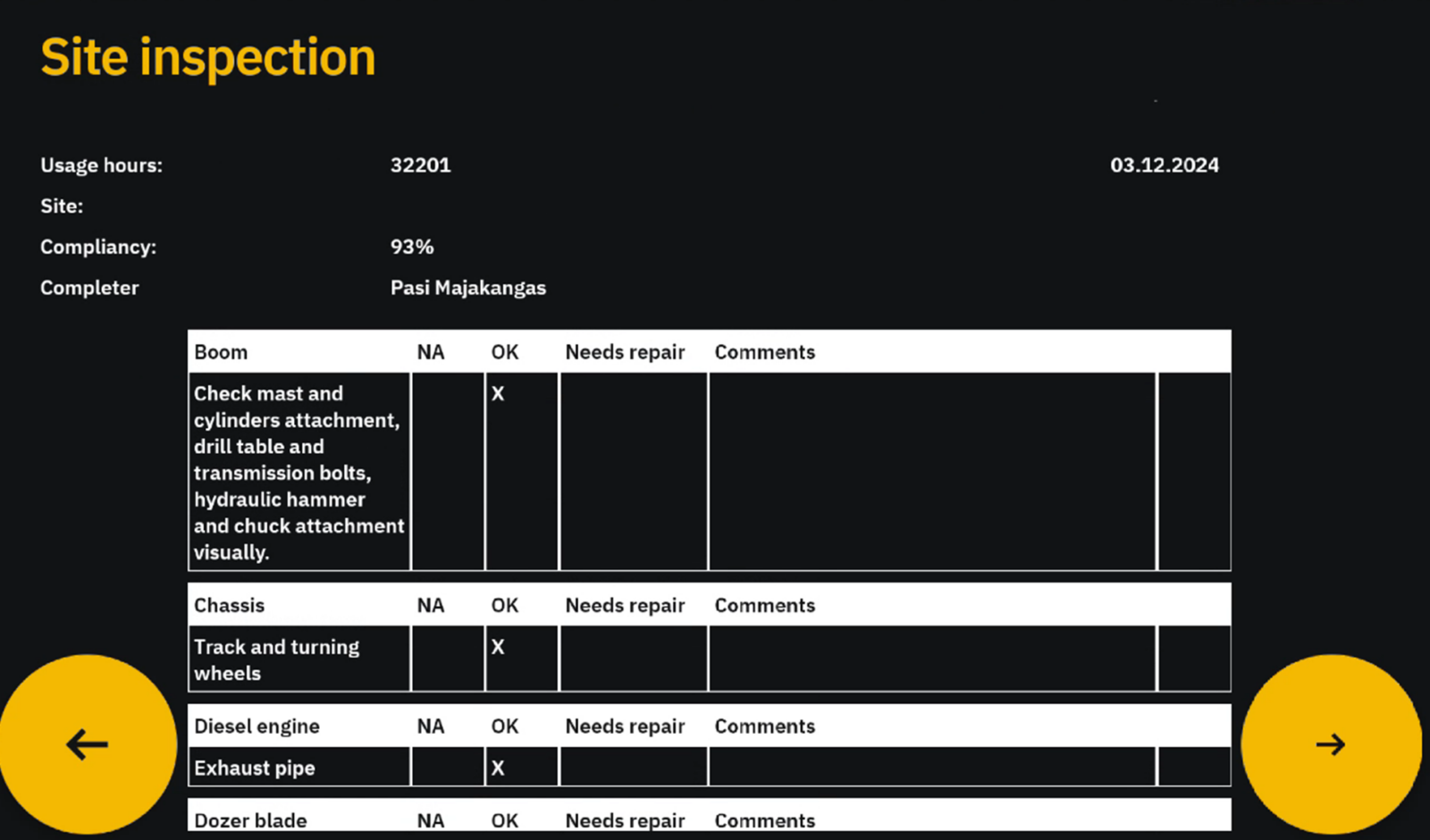
A new intelligent feature has been added to the GMTracker data-logger’s Cloud-version. The digital safety inspection streamlines the process of ensuring occupational safety measures are met, making it easier to comply with safety and quality requirements.
Before starting a soil investigation or well-drilling work, a commissioning inspection must be performed on the drilling rig at the site. For longer-term projects, daily or weekly inspections are also required. The GMTracker data-logger now serves as a tool to efficiently carry out these procedures as well.
Thanks to the new feature in the GMTracker data-logger, the safety inspection process can now be conducted in a standardized, digital format, eliminating time-consuming paperwork. The Cloud version of the data-logger enables real-time reporting of inspection results and any detected discrepancies to all relevant stakeholders. This feature ensures that the inspection history of the equipment, including records of any failed inspection tasks, is securely stored. Inspection task lists are fully customizable to meet user needs.
By digitizing site inspections, Geomachine emphasizes that working safety is just as important as its efficiency, quality, and environmental sustainability. This feature aims to familiarize operators with safe work practices and integrate risk assessment into routine operations. It also ensures that information about working conditions and the safe operational status of machines is always accessible to external inspectors, such as authorities, when required.
International standards ISO9001 and ISO14001 require Geomachine to operate in accordance with the highest quality standards. However, our aim is not only to meet these requirements but also to exceed them whenever possible. Adding the digital safety inspection feature to the GMTracker data-logger is one example of this commitment.
Interested? Contact us!
GMTracker
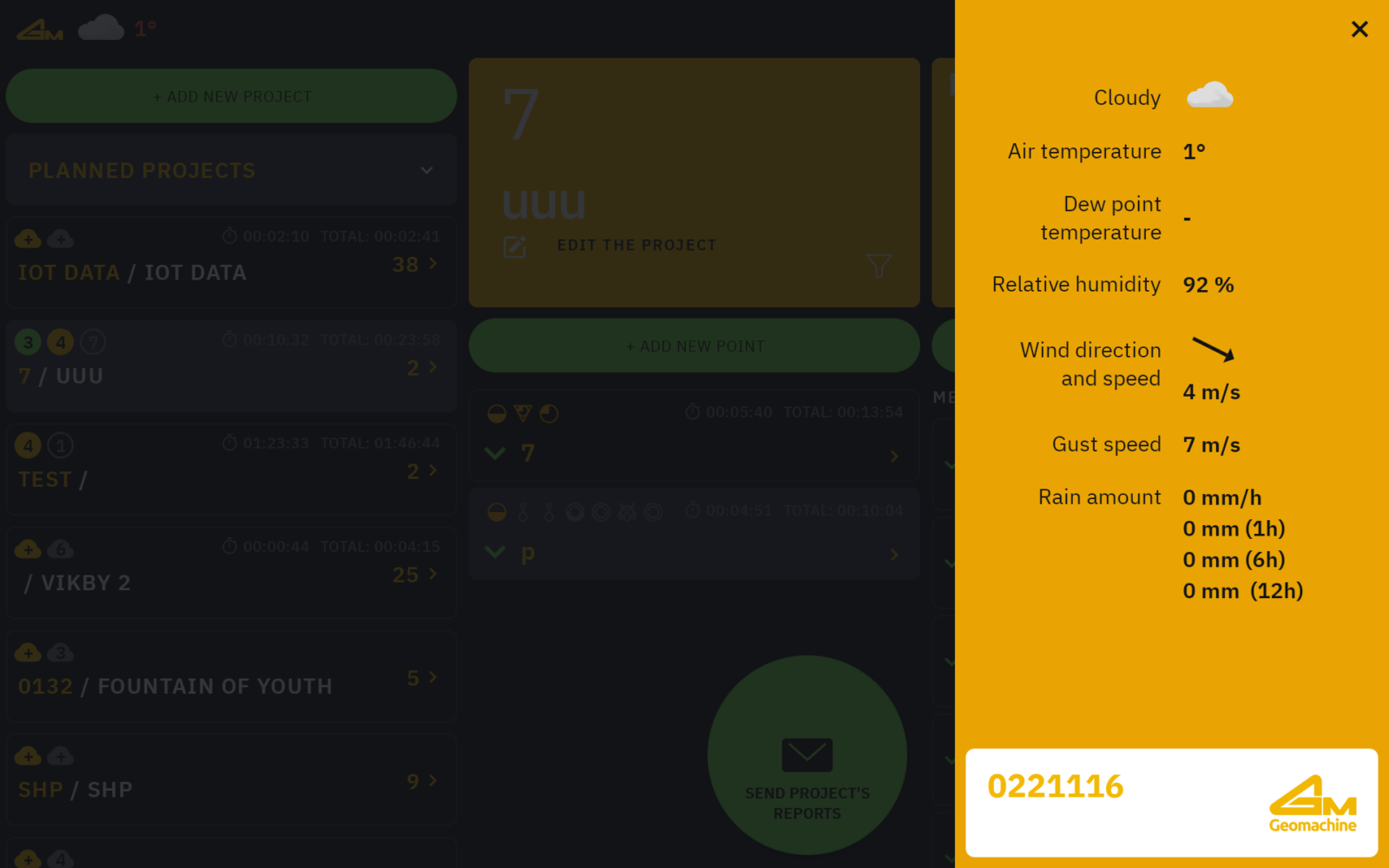
Weather conditions can impact the results of geotechnical investigations, which is why they are documented in the project’s work report. Geomachine has enhanced its GMTracker data-logger with a new feature that records weather data during investigations, allowing this information to be easily integrated into reports.
Geomachine’s GMTracker data-logger is now smarter than ever, thanks to its new weather-tracking feature. This functionality significantly streamlines the work of project managers, as weather information can now be directly copied into the report from geotechnical investigation data. This means that there’s no need to retrieve it separately from a weather service during the report preparation phase anymore.
Using this feature in the GMTracker is straightforward. With the device’s location tracking enabled, the data-logger automatically fetches weather data from a weather service and includes it in the investigation report. Recorded data includes temperature, dew point, precipitation, and wind speed during the investigation.
Geomachine’s GMTracker is currently the only geotechnical data-logger on the market equipped with a weather tracking feature.
Interested? Get in touch!
Vegagerðin
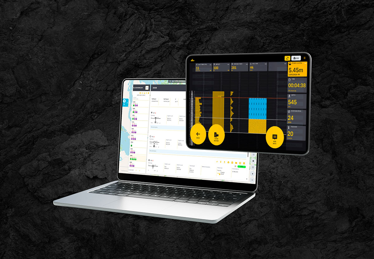
Vegagerðin is an Icelandic state-owned company responsible for managing the country’s roads and infrastructure. The company has recently adopted Geomachine’s GMTrackerCloud service, which enables it to conduct geotechnical investigations in the most intelligent way possible.
Thanks to the GMTrackerCloud service, geotechnical projects can now be carried out more efficiently. The service enables the data-logging, storage, processing, and real-time availability of data for all members of the value chain. “GMTrackerCloud makes the data supply chain smarter,” says Pasi Majakangas, Head of Digital Products at Geomachine. “It reduces the amount of manual work, and the data is always effortlessly accessible to everyone who needs it.”
According to Sverrir Sverrisson, Project Manager at Vegagerðin, GMTrackerCloud is now used by all stakeholders involved in geotechnical projects in Iceland. “Geotechnical engineers upload their drilling plans to Geomachine’s cloud and allocate tasks to the drilling rigs. The field investigator performs the investigations as requested and uploads the data to the cloud service. Geotechnical engineers receive the data in real time from the cloud and can utilize it in their work without delay.”
The activation of the GMTrackerCloud service also eases the workload of field investigators in other ways. “We have implemented a Bluetooth-enabled CPTu solution. This allows the transfer of investigation data wirelessly from the CPTu probe to the GMTracker data-logger. Additionally, we use DGPS positioning, which ensures that the precise location of the investigation point is measured and also saved to the cloud in real time.”
Since Vegagerðin is the sole organization conducting geotechnical investigations in Iceland, the adoption of the GMTrackerCloud service means that the entire country’s investigations are now carried out in a more efficient, high-quality, and intelligent manner.
Interested? Contact us!
GMCare
Geomachine provides its customers with digital services to enhance the efficiency of drilling rigs. The Norwegian company Norconsult Boreteknikk AS aims to improve the utilization and potential of its fleet by implementing Geomachine’s GMCare service.
GMCare is a comprehensive tool for real-time machine analysis. It offers clearly visualized information on machine usage, productivity, safety, and operational condition. This data helps prioritize daily machine-related activities, predict maintenance needs, reduce manual work, minimize unexpected downtime, and thus maximize the productive usage of the equipment.
Norconsult Boreteknikk AS is implementing the GMCare service in all their drilling rigs regardless of the brand. The goal of adopting the service is to automate recurring maintenance processes, reduce the amount of manual maintenance work, continuously monitor the real-time operational condition of the machines, and ensure that this information always reaches the right person at the right time.
The training for using the service will be held in September, and the first user experiences will be shared in October. The GMCare service is also used by Norconsult’s maintenance partner, PTO Teknikk AS, which further streamlines the maintenance of the drilling rigs.
Interested? Contact us!